Last month, the Haringey Council was presented with a plan for School Streets. This is where streets adjacent to schools which are closed to motor traffic in the periods just before and after school opening and closing. This has several benefits: it makes the street just outside the school safe for kids coming and going; by encouraging parents to ditch the school run and have their kids walk or cycle to school, it reduces air pollution and motor traffic, which has benefits far beyond the school in question, since the school run is a major source of road traffic.
It may be helpful here to explain the difference between school streets and low-traffic neighbourhoods (LTNs). The latter are created by simply cutting off through traffic by motor vehicles: modal filters allow people on foot or on bikes (and, if enforced by camera, buses) to pass, but stop most motor vehicles. Low traffic neighbourhoods usually don’t prohibit driving on any of the existing roads, and allow vehicle access to all addresses – it’s just through traffic that’s cut. But LTNs are in effect 24/7.
School streets are both more restrictive, and more limited. They are more restrictive because they do actually prohibit driving on certain parts of certain streets; more limited because they operate only an hour or two each day, and only on days when school is in session. And school streets stop a different kind of traffic. LTNs may reduce the school run somewhat by providing safer places for kids to walk or cycle to schol, but they don’t prevent any particular parent from driving up to the school gate to drop a kid off.
Haringey, until recently, had almost no school streets, putting it in the cellar in a recent ranking of London boroughs (Haringey has had this problem not just with school streets but with active travel – walking and cycling – generally, something I discussed last week in this blog); a few weeks ago it put in one very small one at Chestnuts Primary School. It had received some funding for school streets in London’s COVID emergency funding for active travel, but used this money mostly for footway widening without restrictions on driving – not what would usually be called school streets.
Now, though, we have a real, substantial plan for school streets, with a ranking of projects by the school’s need and the practicality of implementation. An excruciatingly slow rollout (three schools per year, primary schools only) is planned, but with the plans in hand that could be accelerated as opportunities arise. Overall, this is a terrific development, a big step forward by the Haringey Council. I need to say that very clearly because what follows deals with some of the limitations of Haringey’s school street plan.
The plan rates each primary school in Haringey as either suitable or not suitable for a school street; if suitable, some specific measures are proposed. In most cases, the key (and most expensive) measure is the installation of automatic number plate recognition (ANPR) cameras to enforce restrictions on driving.
Here, then, are the limitations of plan as I see them.
Can’t have a school street here – we need it as a rat run
Consider Devonshire Hill Nursery and Primary School, on Weir Hall Road, N17. The Plan says:
The school is not suitable for a school street despite the ‘medium’ air quality and high car usage. Weir Hall Road is not suitable for a school street as the restriction of this street would have significant impact on the operation of the road and surrounding road network as it is the main alternative connection between White Hart Lane and Wilbury Way instead of the A10.
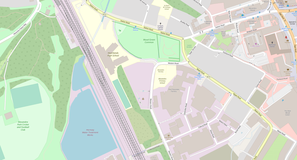
What is this vital link in our motor transport network? On the map below that’s the road running parallel to the A10 just a bit to the east, from White Hart Lane at its southern end to Wilbury Way in the north. Devonshire Hill School is shown as a yellow patch on the east side of Weir Hall, not far from the Rectory Farm Allotments.

The A10 is a high speed dual carriageway. The idea that the smooth operation of the road network requires Weir Hall Road, a simple narrow street running past homes and two schools (the second school is in Enfield, so not covered in Haringey’s report) to serve as an overflow for the A10, shows just dominant the motoring logic is within Haringey’s highways team.
Part of the tragedy – and to say tragedy is not hyperbole: we’re looking here at children’s inactivity and lack of independence, at lungs and brains impaired by particulates, and at a stomping big carbon footprint – is that a non-trivial share of the traffic on Weir Hall Road is to the two schools on it: 24% of the children at Devonshire, a community school, are driven there, probably in large part because its entrance is on a narrow road that many drivers are taking at what speed their little motors can muster, so of course many kids aren’t allowed to walk there, much less to cycle. So we have traffic generating traffic, which is what traffic does.
We see the same thing with other schools. Sometimes the finding is a simple “not suitable for a school street”, as with Devonshire; other times it leads to restricting the school street to a less busy road. I exclude here cases where the busy road is in fact a major thoroughfare. But what is a major thoroughfare, and what is not, may be in the eye of the beholder. 37% of pupils are driven to and form St Martin of Porres RC Primary School on Blake Road in Bounds Green. It is “not suitable” for a school street because
The implementation of a school street in this location would have a negative impact on the wider road network operations as Blake Road is part of the main connection between A109 and Albert Road.
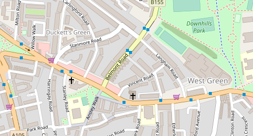
“Part of the main connection” seems to mean “a rat run we use for overflow”. On Map 2, below, St Martins is the yellow patch down a long driveway off of Blake Road, just by the railway. The main connection between the A109 (Bounds Green Road) and Albert Road (B106) should be made by turning onto Durnsford Road (also B106) at Bounds Green. If that route is so busy that Google is sending drivers down Blake Road, perhaps Haringey should get behind the Enfield Council’s proposal to put a bus filter (i.e., no motors except buses) on Durnsford, between Bounds Green underground and the North Circular. I hear, though, that Haringey’s Highways Department actually opposes Enfield’s plan; I can only hope that I am misinformed.

Schools which are “suitable”, but where the most problematic street is left out of the plan because it’s too important as a rat run, include Chestnuts Primary (Black Boy Lane). Chestnuts had been rated “unsuitable” in an earlier draft of the plan but, after a couple of instances of kids being hit by cars and the intervention of parents who are also involved in an LTN initiative in the St Ann’s Ward, a way was found to make a school street on a side road by one of the school’s three entrances. Yet the real problems remain: the Black Boy Lane rat run; lack of bike paths and lack of a safe crossing on St Ann’s Road. In the same ward, West Green Primary is listed in the plan as a priority but no details are given for it; I understand that the planned school street for West Green, like that for Chestnuts, would be confined to a little side road (Termont, in this case), while the problematic rat run (Woodlands Park Road, which also passes by the Woodlands Park Children’s Centre and Nursery) is left as is.

Time now for low traffic neighbourhoods AND school streets. In all of the cases above, and many others besides, the school street solution would be improved by the creation of an LTN. Even with LTNs in those places, you would still want a school street because the LTN just stops through traffic, while the school street limits the use of the school as a destination for car trips. But, while it would be feasible simply to make parts of Weir Hall Road and Blake Road school streets to reduce the school runs there, the school street restrictions would be much less disruptive if drivers didn’t expect to be able to use those roads as rat runs in the first place. Morning school run is the busiest time of day on the roads, so it is feasible to keep non-resident traffic off those roads at those times, it can be done 24/7 with an LTN.
The Weir Hall/Devonshire School and Blake/St Martin’s School situations are relatively simple, because any traffic diverted from those rat runs would go the main roads where it should be in the first place. Cases like Chestnuts/Black Boy Lane, and West Green/Woodlands Park Road, are more complicated because they sit in systems with multiple rat runs, where closing one easily diverts traffic to another. A well-planned LTN can prevent such spill-overs, and encourage an overall reduction in traffic (including, but not limited to, the reduction in school run traffic).
Or consider Rokesly School in Crouch End. The proposed school streets would cut traffic at school run times, which would be a benefit. But the air quality at the school is rated Poor (most schools in Haringey get Medium, which is already not very healthy), and that’s not going to be fixed without filtering the roads around it; these aren’t main roads, but given the structure of the road network in the area filtering will require some planning. That brings us back to finding a way to replace the stillborn Crouch End Healthy Streets project, and to do better than the Council’s subsequent choice (contrary to the balance of consultation views) to go with pavement widening rather than a cycle track on Tottenham Lane. It’s complicated, but the nettle must be grasped.
There are many cases in the School Streets Plan where filtering traffic as part of an LTN plan would make the school street more effective, and probably cheaper. For examples, I’ll return to St Ann’s ward: for a school street on Avenue Road in front of St Ann’s CE Primary School, the School Streets Plan anticipates £26,400 for ANPR cameras and some signage. The LTN proposed by Healthy Streets St Ann’s would include a modal filter on Avenue Road. If that filter were located at the St Ann’s Road end of Avenue Road, the bit of Avenue Road in front of the school could simply be repurposed as pedestrian space, possibly eliminating the need for the camera.
Then, looking just across St Ann’s Road, we find St Marys RC Primary School. Here, the Plan anticipates £55,000, mostly for cameras on Hermitage Road (I’m guessing the difference in cost is because Avenue Road is one way while Hermitage Road is two way, so needs double the cameras). There has long been discussion of a modal filter on Hermitage to improve air quality at that school, eliminate rat runs through a nearby council estate and the adjoining neighbourhood, and improve pedestrian and cycling safety. With a filter on Hermitage, there would be vehicular access tot he school from only one direction, so the school street would not need as many cameras.
As with the Weir Hall/Devonshire School and Blake/St Martin’s School cases discussed above, these are cases where the proposed school streets are currently rat runs. Not all proposed school streets are rat runs, but where they are, the council and the community should always consider whether the rat run needs a 24/7 filter in addition to school streets measures. For St Ann’s and St Mary’s, as for Devonshire and St Martin’s, filtering should reduce driver confusion, improve compliance and reduce cost. Also, if one object is to improve school air quality, the rat run should anyway be closed throughout the school day, which the filter accomplishes.
The long and the short is that much more can be gotten from this School Streets Plan if the borough’s Highways department is on board with a serious program of low traffic neighbourhoods, and traffic reduction in general. Where a highly polluted school apparently can’t have a school street because it’s on a busy road, the solution should not be to label it “not suitable”, but to shift its case to another level of investigation, to ask how motor traffic on that busy road might be reduced. Sometimes it won’t be possible, but in a context of overall traffic reduction, and promotion of active and public transport – the context the Council says we’re in – there will sometimes be ways.
Pavement widening – really?
At two of the schools (Alexandra Park Primary and Bruce Grove Primary), school streets are to be accompanied by build-outs of the pavement “to allow social distancing”. This seems a failure of nerve, if not a misunderstanding of how the school street works: if the school street is functioning properly, the road space in front of the school is a pedestrian zone at the times when children are coming and going. It seems just a waste of money.
In the Alexandra Park case, it may be that the report’s authors recommend pavement widening because they lack confidence in the safety of the school street itself, because of need for access by businesses on Western Road. As far as I can see there are other ways in to almost all but one of these businesses from the other end of Western Road, so I’m not sure what the fuss is about. Pavement widening is a favourite fix by Haringey Highways – it’s a way of doing something for active travel without actually putting in cycle lanes, and indeed sometimes preventing future cycle lanes – and I wonder if the school streets study teams might have been exposed to this virus.
What’s the problem? Parking? Congestion? Pollution? Lack of childhood liberty?
The reports on individual schools were put together by consultants operating under time pressure, during a pandemic, with a new sort of issue to deal with. Haringey has a lot of primary schools. Not surprisingly, there are places where the description of the case and the reasoning for the recommendation don’t really seem to add up. I’ll describe a couple of cases, but before the recommendations are set in stone there really should be a process of school-by-school review.
Bounds Green Primary School has its main frontage on Park Road, with one side of the school facing the very busy Bounds Green Road. About the first of these the report says:
“A site visit highlighted that Park Road is a congestion hot spot with parents parking on the School Keep Clear markings, double yellow lines and in the middle of the road and then conducting U-turns, leading to further congestion.“
Sounds as if Park Road should be a school street, then? Well, no, because a few lines later:
“The location of the school is not suitable for a school street despite the ‘medium’ air quality. The majority of parents observed walked or cycled with their children … there were low traffic volumes observed on Park Road and therefore implementing a school street in this location is unlikely to have a significant impact on operations or air quality.”
Granted that most of the air pollution will be coming from Bounds Green Road; but what happened in the space of a few lines of the report to all of the congestion and illegal parking by parents which, if as described, will surely be having some effect on the willingness of parents to let their children walk or cycle to the school independently? It may in fact be that independent active travel by children isn’t in the remit of the report’s authors – it’s not discussed.
Safety improvements which lower the age at which parents are willing to let their children walk or cycle to school independently are important for two reasons: first, restoring to children some of the freedom which has been taken away from them in the past few decades; second, reducing school run driving by parents whose need to both take a child to school and get to work resolves into a car trip.
This is not the only way in which the report sometimes seems to overlook important benefits that school streets can bring. For many of the schools found “not suitable” for school streets, lack of congestion or lack of school-run-related parking problems are given as reasons a school street is not needed. This misses not only the active travel benefits, as just noted in the case of Bounds Green School, but also the school run’s large contribution to road traffic overall – not just in front of the school.
Sometimes, the report misses low hanging fruit. Coleridge Primary School is slated for a school street, someday, which is good. But the proposal ignores Crescent Rd, which runs between the school and Parkland Walk. Crescent already has a modal filter that stops motor traffic from joining the main road, Crouch End Hill, so perhaps it wasn’t seen as a problem. Yet the stub end of Cresenct Road, with no houses or businesses, now serves as a school run hotspot. It should not be a road, but should be made into parkland, joining up the park along Parkland Walk and the strip of park between Crouch End Hill and the school.

Enough for now!


.jpg)
