Boroughs to the north, south, and east of Haringey have made far greater progress on low traffic neighbourhoods, school streets, and cycle infrastructure. The excuse sometimes given for this is that those other boroughs had more money: Waltham Forest (east) and Enfield (north) were two of the three London boroughs to get Mini-Holland money from TfL; the boroughs closer to the centre (Hackney, Islington and Camden) have more money from developers. And, then, having had a lot of practice and something to show for it, when it came to COVID emergency funds for active travel, those boroughs with better track records had applications that looked more credible.
I don’t think that washes. Of course the borough has money problems. But, when it comes to active transport, it has simply left a lot of money lying on the table because the borough, as an institution, has not been interested in active transport. Consider these examples:
Tottenham Hale (Haringey) vs. Blackhorse Road (Waltham Forest). Two stations, Victoria Line plus surface train; both sites have large new highrise developments. Councils get money – Section 106 funds – from developers to make improvements in the area and to mitigate adverse impacts of the development. In this way, Waltham Forest got money to put in high quality cycle tracks at the Blackhorse Road junction. There’s little indication Haringey did the same at Tottenham Hale.

Getting quality cycle tracks at a big busy junction is a big deal – it’s costly, people with specialist cycle track expertise are needed for design and implementation, and invariably it takes something away from motor traffic. Most main road cycle tracks in the UK just sort of give up at big junctions, leaving cyclists to fend for themselves among turning motorists. It’s a key obstacle to the development of useful networks of safe cycle routes.
Try this experiment: starting somewhere in Waltham Forest – maybe at the William Morris Gallery in Lloyd Park – ride your bike west along Forest Road. Most of this road has segregated cycle tracks, both ways (it is currently being extended well beyond Lloyd Park to the east, including first class cycle tracks through Bell Junction, a busy crossing of two A roads). Actually, what sets it apart most dramatically from roads in Haringey is a small bit where the westbound track is not segregated, but on the roadway. The double yellow lines are accompanied by yellow kerb markings, prohibiting not just parking, but loading.

I’ve never seen this on the (rare) cycle tracks of Haringey, where the council is happy to have cyclists pushed out into the motor traffic by any driver capable of turning on the blinking hazard lights. Those yellow kerb markings are the least expensive part of the cycle track, but they’re of critical importance to creating a network that can be used safely by cyclists of all ages and abilities.
At the Blackhorse Road junction, we see the fruits of the Section 106 money from the developers of nearby tower blocks: cycle crossings, and continuing cycle tracks, in all four directions.

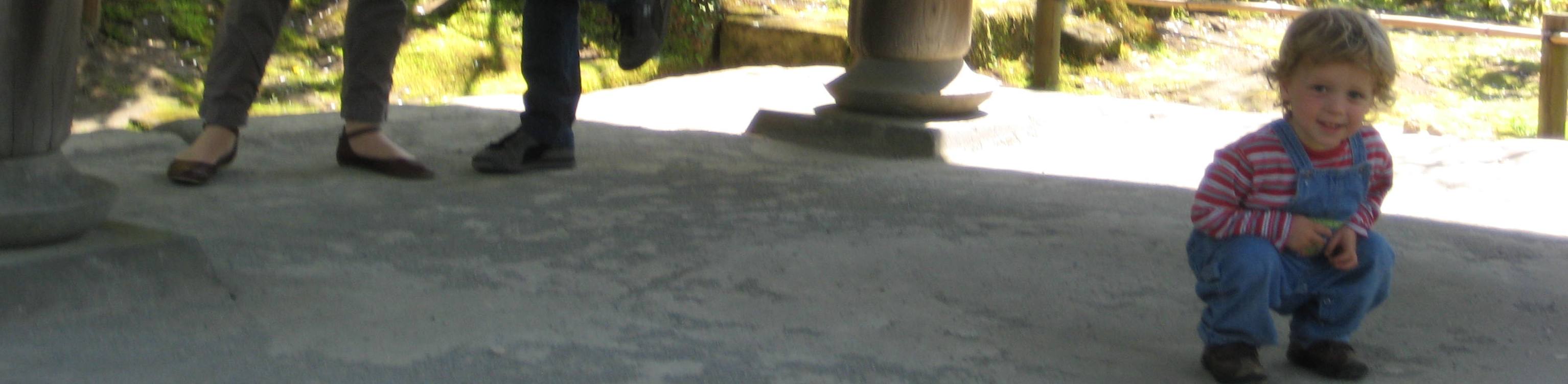
Continue now along Forest Road. It passes some large building works (cycle lane diverted briefly, but still safe from traffic, and continuous), then the beautiful Walthamstow Wetlands (good walking and birdwatching on both sides), and on toward Tottenham Hale. You’ll know when you reach the borough of Haringey because the cycle track first loses quality, and then disappears. The photo below shows the bit of green tarmac that’s meant to suggest a cycle track, but there’s nothing to prohibit, much less prevent, the car in front of me from driving in it.

I’m not holding my breath but, maybe, that will all be fixed as the building work at Tottenham Hale nears completion. But even if it is, you continue past the Tottenham Hale station and the big car-oriented retail complex that the council allowed to be built absurdly at a transport hub, sandwiched between high density housing developments (high density even before the new tower blocks) and nature reserves. Why allow a car magnet here? But I digress. Make your way around that car park and rejoin what is meant to be a cycle track along part of Broad Lane, the road from Tottenham Hale to Seven Sisters. This track shares the pavement: here it’s marked separately from the footway; there it suddenly becomes “shared space” where pedestrians and cyclists are expected to spontaneously agree to rules for peaceful coexistence; in part of that shared space a bus shelter sits in the middle of the path with no clear indication of how to proceed; and, at several points, side roads or driveways are given priority over the pedestrian and cycle traffic, with drivers pulling straight up and blocking the path. In Waltham Forest, cycles would be given priority; cross to our side of the Lea, and it’s cars.

The problem with the Broad Lane cycle track is not lack of money: it did not cost less than a good cycle track would have cost. The problem is that Haringey prioritises cars, both moving and parked, over other forms of transport.
Railway bridges. In 2017, Wightman Road was closed to through traffic for several months while the bridge across the Gospel Oak-Barking railway was replaced, at a cost of I don’t know how many millions of pounds to Network Rail. Residents of the area, thrilled with the sudden lack of traffic, rallied to urge that the closure be made permanent.

Now, this was actually a great opportunity for Haringey. The old bridge was perfectly safe for pedestrians and cyclists. The council could have offered to Network Rail the repurposing of the bridge for pedestrians and cyclists only, so that the costly replacement was no longer necessary, on condition that Network Rail share some of the savings with the council. That, in fact, is what the borough of Waltham Forest did in the case of two bridges over the same railway line, helping to create (and finance) two of their early Low Traffic Neighbourhoods. Here’s one of them, not far from the Blackhorse Road station:

Haringey council instead spent a substantial sum on a big study of what to do about traffic on Wightman and in the Green Lanes area overall – roughly, the wards of Harringay and St Ann’s. Many suggestions for traffic reduction measures came from the public and, of those that the council allowed into the questions on the final consultation, steps most respondents favoured included getting rid of through motor traffic on Wightman, making the southbound bus lane on Green Lanes 24/7 rather than just weekday morning commute, and getting rid of parking to make room for a northbound cycle track on Green Lanes. The council decided to do none of that, and to make minor improvements to Wightman. This was not for lack of money, but because the politics of getting rid of parking on Green Lanes were too much for the council to stomach. I wrote some blogs about it at the time: Deference to Traffic, and Deference (again) to Traffic (the titles do give away the ending, though).
By the time all of this study-and-inaction was finished, of course, the millions to replace the old railway bridge had been spent.
The Belmont-West Green-Langham triangle
We could say that’s all water under the bridge, but the fact is these things are ongoing. Right now, boroughs all around us are transforming neighbourhoods so that drivers can’t take rat-runs through them. COVID emergency funds were being given out to help with this process, though Haringey’s applications for such funds were turned down. But sometimes Haringey gets other funds that could be used to create low traffic neighbourhoods, if it really wanted to do so. For instance, it has just received from TfL £80,000 on some road safety improvements in this area:
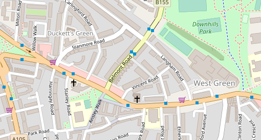
Belmont Road and Langham Road have been the site of numerous injuries to pedestrians at the hands of drivers. Langham Road is an extremely busy rat-run. Langham has relatively high density rental housing and passes by one entrance to Park View Secondary School. Traffic queuing to turn from West Green Road into Langham further fouls the air, and delays buses. Stanmore Road is also a rat run.
Two or three very simple traffic filters would solve this, keeping the through traffic on the main (A & B) roads, and making both Langham and Stanmore into safe places for kids. Elimination of a few parking spaces would make space for a right turn lane from West Green to Belmont, preventing traffic delays on West Green there. Haringey Council estimates traffic filters cost about £30,000 per junction on average, but other sources put that at about £20,000. Two small low traffic neighbourhoods could be had (or at least tried) at well within the £80,000 budget for the safety project.
What’s the Haringey Council doing with the money? Putting in traffic bumps on Belmont and Langham. The cars will still come, with the SUV drivers hardly noticing the bumps and other drivers producing more noise and pollution than ever with the slow-down-speed-up rhythm that speed bumps give us.
As far as I can tell, traffic filtering options were not even considered by the council. They were not included in the consultation on the project. This will not surprise anybody who has observed the Haringey Council over time: those in the council who make decisions about roads and traffic do not like filters. They can say it’s for want of money, but they find money for speed bumps, which are not cheap.
The same thing seems to be happening with improvements to the amusingly named Cycle Superhighway 1 (a route that roughly parallels the Tottenham High Road, sometimes on the pavement but mostly on back streets). This is one of the bits of COVID emergency active travel funding that Haringey was successful at bidding for. I have not seen detailed plans (as far as I know they have not been published), but it looks as if, again, they are passing up opportunities to use those funds for filters that would serve the dual purpose of making a far better cycle route and at the same time create some people-friendly streets. I’ll get back to that when I have more information.
But while we wait to learn that, we already know enough. Yes, the council is short of funds. But that is not the reason drivers rule our streets and our air is toxic: the reason is that the people who make these decisions at the council don’t make active travel a priority and don’t make clean air a priority; they resist solutions which would confine through traffic to main roads, while making most roads safe again for children and for other people who breathe; and they resist solutions that would reduce parking and loading to make space for cycle tracks. We get a lot of fine words from the council about active travel, clean air and reduced carbon footprint, but actions speak louder, and this council’s actions speak all too clearly.
(When I say “the people who make these decisions at the council”, I’m not being coy in not naming names: I see what the council does, and write about that; who makes the calls is not something I see, and I’m not inclined to speculate.)


.jpg)
