New Green Lanes area traffic consultation is now available. There are some good elements to it, worth supporting, and there are tweaks that are worth proposing. The consulation documents outline some complicated and contentious issues concerning bikes and parking on Green Lanes, and what to do with Wightman Road. Overall, however, the proposals are timid: they do not contemplate or attempt any substantial reduction in traffic, which is to say that they don’t really set out to solve the problem the plan is meant to address. Haringey surely can do much better.
My next post will be an item-by-item set of recommendations for answering the consultation. First, in this post, I want to say why I call the proposed measures timid and inadequate, and what I think could easily be done to improve the bigger recommendations.
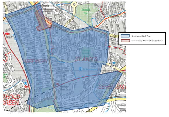
The consultation deals with the area shown on the map above: south of Turnpike Lane and West Green Road, north of Finsbury Park and the New River, east of the mainline railway, and west of Avenue Road.
Whose traffic problem?
Contrary to what the consultation – in both its traffic models and its rhetoric – assumes, we know that traffic can go down as well as up. According to the consultation’s own figures, use of cars for commuting by residents in the study area keeps falling: from 27% in 1991 down to 15% in 2011. In 2011, 61% of households in the study area had no car, up from 53% in 2001.
People making trips to the area “for shopping, personal business and leisure” are likely to walk or cycle (50%), take the bus (17%) or the Tube or train (10%): just 23% as drivers or passengers in cars. A very large slice of that 23% would be accounted for by people driving to the Sainsburys and the Arena shopping park, not to local small businesses.
In short, residents and local businesses don’t account for much of this traffic, and our contribution to traffic has been falling. Yet we breathe the fumes and our bus service keeps getting slower and there is no real progress on safe routes for cycling or safe routes to school in Haringey. The options in the consultation don’t offer much help in solving these problems.
Traffic filtering and traffic evaporation
People can deal with such problems. They are doing so in many cities around the world, but for a sterling example we need look no further than the neighbouring boroughs of Waltham Forest and Enfield. These boroughs are two of the three outer boroughs that participating in TFL’s Mini-Holland project. It gets its name from Holland because that country has done more than any other to provide safe routes for cycling – it is normal for kids in Dutch cities to cycle to school, for instance. The biggest part of the mini-Holland programme is not cycle tracks (though they have those), but traffic filters to cut rat runs on residential streets – much like what we have in the Gardens or Hermitage Road, but in the mini-Holland cases applied systematically across large areas of the borough.
Last November, traffic flow figures came in for the impact of first Waltham Forest Mini-Holland filters, on ten roads in the Walthamstow Village neighbourhood. It found that they had produced an overall reduction in traffic of 16% in that neighbourhood, including the adjacent (unfiltered) main roads. There was a slight increase in traffic on the main roads, but this small rise was swamped by massive reductions on the filtered residential streets. Result: cleaner air, and far better conditions for walking or cycling to school in that neighbourhood. The programme continues to roll out over other Waltham Forest and Enfield neighbourhoods, and observers report an immediate rise in kids playing (safely) in the streets.
What is happening in Walthamstow is known to traffic engineers as traffic evaporation. It can happen for two reasons. One is that what look like short cuts to individual drivers wind up, taken together, making the traffic system more complex and through-trips more circuitous – in which case cutting out the short cuts can mean less traffic. Just picture somebody coming through your road with one eye on Waze or some other route-finding app, taking one unfamiliar turn after another, trying to avoid traffic somewhere: maybe, just maybe, this will speed up the journey of that individual, but it’s likely to increase the overall miles travelled on our roads. Filtering can stop that. The other is that with the removal of routes, some local car trips just didn’t happen. For instance, a major objective of the Waltham Forest mini-Holland has been to replace the school run with journeys by foot or bike.
The traffic models used in the Green Lanes study assume that the overall volume of traffic is fixed, although there is good evidence that more roads or routes will produce more traffic (“induced demand”), and that limiting routes will produce some evaporation. The reason these factors aren’t modelled is that they are very hard to predict – they result from thousands of human choices that follow from a change in the transport system, responses which depend on the specifics of the situation, not some general law of traffic. Such responses can really only be determined by experimentation. Fortunately, in the case of traffic evaporation the experimentation isn’t too expensive: it’s just a few bollards, or a couple of enforcement cameras.
Traffic filtering between West Green and St Ann’s (not)
Many of the early study documents included proposals to actually remove existing traffic filters from the Gardens and from Hermitage Road. Results of the first round of consultation went strongly against that, and we can be glad that such proposals were dropped. But no options for new filtering were added (except on the elaborate menu of options for Wightman Road): the council is going for the status quo.
As recently as last December, the study’s steering group was actively considering a proposal to add new filters on all the north-south routes between West Green Road and St Ann’s Road. Four roads there have a lot of through traffic on them: Woodlands Park, Black Boy Lane, Cornwall Road and Avenue Road. Filtering these (and also of course alternate, more circuitous routes through the same neighbourhoods) would have vastly expanded safe routes to the several schools in that area, improved air quality, and could very well have reduced overall vehicle traffic coming to and from Green Lanes from the east and northeast.
Here’s what the study has to say about the filtering alternative, which the Council decided not to include as an option for you to consider:
Based on feedback received during the study, there is a desire to reduce north-south traffic using residential roads between West Green Road and St Ann’s Road. This is primarily due to certain north-south roads carrying high flows of traffic. Black Boy Lane is particularly busy, carrying over 10,000 vehicles per day. Cornwall Road and Avenue Road each carry about 4,000–5,000 vehicles per day, whilst Woodlands Park Road carries 3,000–4,000 vehicles per day.
Based on this, we considered how this issue could be addressed:
- A full closure to all north-south traffic though the area between West Green Road and St Ann’s Road would be possible, but would require several road closures. This would create a very large gap between adjacent north-south routes (the distance between Green Lanes and Seven Sisters Road is approximately 1.7km). It would also be difficult to close Black Boy Lane, given that it is used by bus routes.
- Alternatively, some partial closures would be possible, although this would simply displace north-south traffic onto the roads that remain open. For example, if Cornwall Road and Avenue Road were closed to through traffic, then this would simply displace even more traffic to Black Boy Lane. This would worsen the equitable distribution of traffic on residential roads between West Green Road and St Ann’s Road.
Based on these considerations, it has been concluded that short of closing all north-south routes through the area, the current situation would be difficult to improve upon, as it at least distributes north-south traffic across four roads (Woodlands Park Road, Black Boy Lane, Cornwall Road and Avenue Road), albeit in an uneven manner. The main improvements that could be made relate to traffic calming to moderate vehicle speeds….
They exaggerate a bit on the hopelessness of closing-one-one-route-unless-you-close-all, but it is true that these rat runs are close substitutes, so it’s far more effective to close all of them at once.
But, contrary to the study’s claim, closing all isn’t actually a problem, because Black Boy Lane can be filtered to most traffic and still have its bus routes. One way to do this is with rising bollards. A quicker and cheaper option is what Waltham Forest did on one of the first roads filtered in the Walthamstow Village: Orford Road is closed to non-bus traffic most of the day, with no bollards or barriers at all. A camera does the work. A handful of motorists do choose to violate the ban, but they don’t amount to much traffic and the fines they pay have become a nice little earner for the council.
As for the “problem” of no north-south route for the 1.7 km between Green Lanes and the Tottenham High Road – there is a very good chance that that is a feature, not a bug: we want less traffic on Green Lanes, and many of the cars cutting though these north-south routes are coming to or from Green Lanes (down Woodlands Park or Black Boy Lane, up Salisbury Rd or St Ann’s, to Green Lanes: watch it sometime). Of course, if none of the traffic evaporates, it would still bother somebody somewhere, but there is a good chance that much of it would evaporate – precisely because of the 1.7 km span of the barrier to through traffic.
Lack of filtering, and safe routes to schools
The first section of the consultation deals with “area-wide improvements”, and one of these is headed “Minimise impacts of school run”. The supporting documents proclaim laudable objectives:
… to encourage the use of sustainable modes of transport to travel to school and discourage unnecessary vehicle use.
… measures to reduce the negative impacts of vehicle traffic on schools, in the areas of road safety and pollution
It then gives a couple of nice illustrations of programmes in other places (neither of them in Haringey) and then … proposes nothing:
The specific measures implemented at each school will need to be bespoke.
Any measures should also be implemented with the support of each school community and nearby residents.
This ‘bespoke’ business both sounds really nice, like a good suit, and at the same time avoids having to propose any action whatsoever, because the traffic plan is dealing with things on a larger scale than that, right?
Yet if you wanted to minimize the impact of the school run at schools in, let’s just say, the area between West Green Road and St Ann’s Road, the best place to start would be with exactly what the council has decided not to include as an option in this survey: filtering the north-south roads to eliminate through traffic of private motor vehicles. Apparently, there was some significant support for this among nearby residents; otherwise, the report wouldn’t have bothered with such an elaborate – if unconvincing – rationale for omitting this option from the list we’re consulted about. Such filtering is a big part of the school run minimization in the mini-Holland boroughs. Can it be done as a bespoke measure for a particular school? I suppose that parents at Woodlands Park Nursery and West Green Primary might get together to call for filtering Woodlands Park Road, to reduce traffic and, air pollution at their schools. But that’s one of the north-south roads that the same study says can’t be filtered one at a time – we’ve been told it’s all or nothing.
So apparently the council’s vision of minimising the impact of the school run doesn’t extend to filtering traffic on busy roads near schools, which leaves a pretty limited menu for action on the issue. Or perhaps we should just treat the school run section of the consultation as window dressing. And we do need to grant that the council is in a tough spot here: if you’re talking about traffic you can’t be seen to ignore traffic’s impact on active travel to school, or of school air quality; yet, if you’re wedded to the belief that overall traffic can’t, or shouldn’t, be reduced (and indeed that it will continue to grow), there’s really very little you have to offer. So we can understand why the Council would kick this into the longest of long grass, not even making it an item for future study but just saying “bespoke”. Sadly, it doesn’t solve any problems.
More missing filters: Wood Green
Most of the traffic cutting through our area, or into our area to shop at Sainsburys/Arena, is travelling roughly north-south. Some of it comes straight through Wood Green, either along Green Lanes, or along Hornsey Park Road. Most readers will be aware that the Council has big plans for Wood Green, with a lot of tall buildings and a big increase in population. The area has two tube stations, two train stations and numerous bus routes in place, and both a Piccadilly Line upgrade and Crossrail on the horizon.
The combination of the excellent, and improving, public transport with the high and rising density of development calls out for a big reduction in the use of private motor vehicles. Yet, it is clear from the Council documents that their current thinking is not to cut motor traffic in the area, but to allow it to rise: Green Lanes between Wood Green and Turnpike Lane would still have cars and vans as well as buses, and traffic on Hornsey Park Road (the northern extension of Wightman Road) would be allowed to rise as well. In light of this, perhaps I have been unkind to those drafting the Green Lanes plans, when mocking their assumption that traffic will increase: I had suggested that this was due to a belief that more traffic was inevitable, as if a law of nature, but it may be instead that more traffic is what they intend.
Be that as it may: I have argued elsewhere that, as part of Wood Green’s “regeneration” (scare quotes, because the plan as it stands is a bit scary), there should be no private north-south traffic through Wood Green. As always, some drivers faced by such a filter will just go around, and wind up on Green Lanes or Wightman anyway. Others will … evaporate. The Wood Green consultation has been extended, and is open until 28th April, and if you’re worried about traffic on Green Lanes or Wightman, you should answer it.
Missing filters: The Ladder
Most roads on the Ladder are rat runs, and singularly unproductive ones: drivers seeking to avoid traffic on Green Lanes race down Wightman until they judge they’ve come to the right place to cross over, to get nearer to the front of the Green Lanes queue where it reaches some bottleneck. It’s all a bit like drivers passing a motorway tailback in the breakdown lane, and then insisting on merging in at the last-minute just before whatever is holding everything up – except instead of breakdown lanes we have Wightman and the Ladder Roads, where people live and kids go to school.
One of the most unexpected and encouraging proposals in the Green Lanes plan is the reversal of one Ladder road, Warham. This should sharply reduce traffic on Warham, and interrupt the heavy traffic that now goes from from St Ann’s, up Salisbury, and up Warham, to Wightman. However, with the Ladder roads as with the roads between West Green and St Ann’s, substitution is easy – make use of one road impossible, and traffic can move to another. How much traffic will now turn onto Green Lanes from Salisbury, and then off onto a Ladder road at the first opportunity, but congesting Green Lanes in the meantime, remains to be seen. So the practicality of the proposal is questionable. The reason I am pleased to see it is that I had assumed that this traffic-besotted Council would hold the Salisbury-Warham traffic flow sacrosanct, and they seem willing to let it go. If you can let that go, you can let through traffic on any Ladder road go.
Is it feasible to simply filter all the Ladder roads? For the five northernmost – those along Duckett’s Common – it would be easy, with a single gate or set of bollards where Frobisher Road meets Green Lanes. For the rest, there would be more difficulty with larger vehicles turning around to get out. If there were a filter near the middle of one of these roads (at the Passage?), it might need a turning circle – with roadway and footway on the same level, to get a big enough radius – at either side of the barrier. It’s a problem that has been dealt with, one way or another, in many settings in many cities, and I’m sure a way could be found. The best way to find it would be to experiment with filtering one or two of the roads – perhaps those to either side of one of the schools. Find out what works, then extend to the rest of the Ladder.
But you won’t find anything about filtering Ladder roads in the consultation, so if you want that you’ll need to write in into the “further comments” box.
Missing filters, again: Hermitage Mark II
There are filters on Hermitage Road and Vale Road which keep parts of these roads from being rat-runs, but that doesn’t stop traffic coming through from Seven Sisters Road, up Vale to Hermitage to St Ann’s. The last bit of Hermitage goes past St Mary’s Infant & Junior School, which has sometimes appeared on lists of the borough’s schools with exceptionally bad air quality, and where the heavy traffic makes for an unsafe school run scene. Hermitage is also meant to be a cycle route – connecting at St Ann’s Road with North Grove – but for the same reasons does not feel safe. The Council is proposing is to widen the pavements where Hermitage passes under the railway, which would also slow traffic a bit but leave it a rat run with far too much traffic. This road, too, needs filtering.
Turnpike Lane-Wightman Road junction: throwing up of hands, again
I’ve discussed this junction in my previous post on Wood Green regeneration plans, and won’t repeat what I said there. Here I’ll just say that when it figures in the various Wightman Road options, it again illustrates vividly the sad results we get out of a combination of traffic models which assume fixed levels of traffic (no evaporation) and a Council that can’t see progress happening without road traffic growth.


Pingback: Green Lanes Consultation: Item by Item | Frederick Guy
Pingback: But where will the Wood Green traffic go? | Frederick Guy
Pingback: Haringey Transport Strategy vs. Green Lanes Report, or, deference (again) to traffic | Frederick Guy
Pingback: Can Haringey not afford safe streets? | Frederick Guy